

qathet Regional Coastal Flood Adaptation Strategy
The qathet Regional District successfully secured provincial grant funding through the UBCM Community Emergency Preparedness Fund to complete a Regional Coastal Flood Adaptation Strategy (RCFAS).
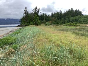
As climate change occurs, many coastal communities are recognizing and planning for the impacts from increasing flood and erosion risk due to sea level rise and coastal storms. Building on previous flood mapping along our coastlines, the qathet Regional District, Tla’amin Nation, and the City of Powell River are now working together through development of the RCFAS.
This spring, we will be hosting community information sessions, a game night, a survey and a public workshop to engage with local residents about the impacts of climate change along our shoreline and what can be done to adapt and build resilience. Feedback gathered between now and June 2022 will inform the development of the RCFAS later this fall.
Please check qathet.ca/current_project/regional-coastal-flood-adaptation-strategy/ updates on this project, or click here to sign up to receive updates by email.
How you can get involved
Attend upcoming events
You are invited to attend a virtual community information session on April 13, 6:30 – 8:00 pm to learn more about coastal flood and erosion risk along our shoreline, and tell us what matters to you.
Note that a separate session will be held specifically for Tla’amin members and lease holders on April 12, at 6:00 pm. To attend that session, please contact Carmen Galligos (email: [email protected]; phone: 604-483-9646 ext. 150).
Join us for a virtual Flood Resilience Game Night on April 27, 6:00 – 8:30 pm to practice adaptive decision-making, and have some fun!
We are also available to provide presentations to community-based organizations at your scheduled meetings in April – please be in touch to request a presentation at [email protected].
A public workshop will be held on June 22, 2022 at Willingdon Beach Park to explore adaptation options together and inform proposed strategies.
Complete the online survey
A brief online survey will be available from April 13 to April 29, 2022 on the project webpage.
We invite you to share your concerns and what matters most to you regarding coastal adaptation.
Paper copies are available upon request. Please call the qathet Regional District planning staff at 604-485-2260 or email [email protected] to get your copy.
Stay up to date
Sign up here to get regular project updates.
Learn more
Adapting to coastal flood and erosion risk
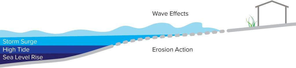
Through this work, we will explore how sea level rise and a range of coastal storms (both small and frequent, as well as large and rare) interact with the places and things that communities value along the coast.
Put simply, sea level rise is caused by expanding ocean water as it warms and increased melting from ice sheets and glaciers. As ocean water rises, coastal communities are more likely to experience flooding than in the past. This is especially the case when sea level rise combines with high tide as well as coastal storms (i.e. storm surge, and wind and wave effects). More frequent coastal storms and rising sea levels can also increase coastal erosion, which acts to remove sediment and rock from the shoreline.
Of course these changes don’t happen on their own: they combine with other factors such as land use, economic activity, ecosystem health, cultural values and our ability to adapt and change, to determine where and how vulnerable our coastlines are to coastal flooding and erosion. This tells us the level of risk we face in particular locations, and informs which adaptation actions we might want to prioritize.
Note: This project focuses on the coastline and does not address flooding or erosion from extreme rain events or along inland streams, rivers or other water bodies.
Attend an information session or visit the Resource list to learn more.
Work to date
We have already conducted two initial coastal flood assessments at various scales to understand where and how flooding and erosion may impact our shoreline. Coastal flood mapping and a risk assessment were completed by Tetra Tech Canada Ltd in 2018. That study identified priority areas at risk due to impacts to people, critical infrastructure and the environment.
Since then, more detailed coastal flood mapping has been completed for the prioritized areas on the mainland and islands in 2021. The more recent mapping considers coastal storms, sea level rise projections through the year 2100, and coastal erosion potential. These assessments will be enhanced and used to inform the engagement efforts this spring and contribute to the development of the RCFAS later this year.
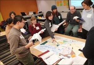
Importance of community engagement
A collaborative approach is at the core of this process. This work involves complex decision-making around how we adapt to and reduce coastal flood and erosion risk. Community engagement is an important value guiding this work to ensure transparency and enhance our collective understanding of risks facing our shoreline and options for addressing them.
Resources
Below links are external
- BC Adapts Short Videos
- BC Adapts: Planning for Sea
- Relative sea-level projections for Canada based on the IPCC Fifth Assessment Report and the NAD83v70VG national crustal velocity model
- Sea Level Rise Adaptation Primer
- Canada’s Marine Coasts in a Changing Climate
- Climate Data Canada
Acknowledgments
Photos provided by Tetra Tech and Ebbwater Consulting.
![]()
Website: www.qathet.ca